Thursday, February 21, 2013

Morne Diablotin, Dominica


Friday, February 8


After a day of rest, we were ready for more hiking in Dominica. We had planned another guided hike with Ken to the top of Morne Diablotin which is the highest peak in Dominica. It took about 30 minutes to get to the start of the hike, driving through orange and grapefruit groves. As soon as we got out of the van to begin the hike, it started to rain, and unfortunately, the rain didn't stop all day. The hike was about 3 miles up to the top which basically went straight up; tons of log steps for the first mile and a half, and lots of mud puddles. Our hiking boots were completely covered in mud after the first 30 minutes of the hike. It was really interesting to see the vegetation change as we moved up the mountain. The top half of the mountain contained shorter bushes, rather than trees, with thick dense leaves. For the last half of the hike, we were climbing straight up the vines of the trees/bushes and the rock of the mountain. When we finally arrived at the top, we found ourselves within a cloud and surrounded by clouds. The rain stopped just long enough for a picture, but there was absolutely no visibility since it was such a cloudy day. After waiting for a while in hopes that the sun may come out (without any luck), we headed back down the mountain, making it back to the van much faster than we had on the way up. Gene and I agree that this was probably the muddiest hike we've ever done, with mud practically filling our shoes, socks, and all over our legs and shorts. We were happy to be back on the boat later that day to jump in the ocean and clean off all the mud.

Start of the trail


View from the top (in a cloud)

Hiking down

Showing off our mud-covered shoes / legs

Friday, February 15, 2013

Tour of Dominica & Sari Sari Waterfall Hike


Tour of the East Coast & Sari Sari Waterfall
Wednesday, February 6

We woke up early and met up with our guide, Ken, for a tour of the east coast of the island. He drove us around in his tour van, stopping at various view points and providing details on each of the towns we passed. The east coast of Dominica has some great reefs, and interesting rocky cliffs and rock formations, but there aren't any bays suitable for anchoring. 


Northeast Coast of Dominica


Hell's Gate (Rock Formation) and Calibishe


Pit stop for some coconut water and fruit


A large section of the east coat is part of the Carib Indian territory. The Caribs that live on the reservation today are farmers and craftsmen. They have roadside craft markets where you can buy handmade baskets, jewelry  masks, carvings, and other souvenirs that they've made out of palms, coconuts, bamboo, and other local plants. The Caribs harvest a crop called Cassava which is a root that they grind into flour and use to make bread. We stopped at one of the bakeries in the territory and bought some of the cassava bread.

Cassava Bakery

This is where the Carib Indians grind the root into flour

Bagged flour ready to be sold at the open market


As we continued our tour, we stopped at various spots along the road where Ken pointed out coffee and cocoa trees, guava, bread fruit, cinnamon trees, bay trees, pineapple farms, and other local crops. Banana trees are the most prevalent – after tourism, export of bananas is the second largest industry in Dominica. There are 7 different types of bananas that grow in Dominica, two of which are vegetables.

Coffee bean tree

Coca tree (Ken's climbing up the branches to get us a pod)

Commercial banana trees 
(Bananas are wrapped in blue plastic to protect from insects)

Poinsettia tree

Guava tree (Ken's climbing again to get the fruit)

Pineapple farm


We stopped for lunch at a beautiful restaurant that overlooked the coast. While we were there, we met another couple that was traveling in Dominica, specifically there to do some bird watching. It turns out that they were from Atlanta, and their children are around the same age as us - their son also graduated from Georgia Tech, a few years before us. We enjoyed swapping stories with them about our travels.

View from our table looking out over the east coast

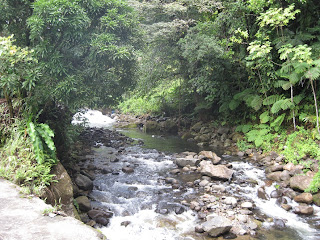
One of the many rivers on Dominica (365 total rivers)


After lunch, we continued the tour to the start of a hiking trail that leads to the Sari Sari waterfall. We were ready to get out of the van and do some hiking. The hike along the 2-mile trail was a beautiful hike through the lush rainforest. There were a couple of river crossings and many passages along mountain sides, with thin parts of trail cut into the sides of a mountain that dropped straight down. We finally arrived at a sign pointing towards the waterfall. When we turned the corner, the sight was spectacular! We were surrounded by the mist from the falls even a couple hundred yards away from the base pool. Sari Sari is the second tallest waterfall in Dominica after Trafalgar Falls, and it really is breath-taking. We climbed our way over the boulders and through some treacherous mini-falls passages, and we arrived at the base pool of the waterfall where we were able to swim around the pool and under the falls. After a while we headed back to the trail, hiked back to the van, and enjoyed the ride through the rainforest roads back to the dock.


Start of the trail

River crossing

First view of Sari Sari Falls

Gene at the bottom of the falls


Gene and Ken

View of the town of Mero and the West coast of Dominica


Indian River; Portsmouth, Dominica

Tuesday, February 5
After spending most of Monday checking into customs and exploring the town of Portsmouth, we were ready to do a tour up the Indian River. I got in the kayak and tracked down one of the PAYS boat boys, Ken, who was happy to give us a tour of the Indian River.
The Indian River is one of the must-see attractions of the Eastern Caribbean. It was used for several scenes in the second Pirates of the Caribbean movie which the locals love to brag about. The river is protected by the national park association in Dominica so they don't allow any motorized boats to travel up the river. They require non-locals to pay for a nature ticket to explore the Indian River which helps pay for the association the protects and preserves the area.
As you enter the mouth of the river, you can see the color difference in the water indicating the mix of fresh and salt water. There are a couple of smaller rivers that branch off of the main Indian River channel that our guide, Ken, took us through. All along the banks of the river, huge swamp bloodwood trees grow and create a canopy of the river. The swamp bloodwoods have massive trunks with roots that spread out and twist in interesting wavy designs. There are also thousands of tall palm trees that add to the canopy, and tons of young palms growing out of fallen coconuts. It was really beautiful and peaceful gliding down the river. Ken pointed out a few different species of birds, and there were lots of trout and blue crabs in the water. As we got further down the river, it begins to narrow, and at the furthest spot along the tour, there is a jungle bar with beautiful gardens and fruit trees. We got out of the boat and walked around the gardens, and of course tasted the local rum punch drink (called Dynamite). After a couple of Dynamites, we headed back to the boat and finished the tour, heading back down the river and out to the ocean. As we left the river, we realized that it's possibly to go through the river without a guide so long as you've purchased a nature ticket, so Gene and I decided that we would come back another day in the kayak to explore the river on our own.Ken dropped us back off at our boat and we invited him aboard to discuss some other tours we could do with him later in the week.


Rowing up the Indian River 

Swamp Bloodwood tree

Kat and Gene at the Indian River jungle bar gardens

Ken breaking open an almond seed


End of the Indian River


Sunday Night Cruisers BBQ in Portsmouth, Dominica

Sunday, February 3

We arrived in Portsmouth, Dominica on Sunday afternoon, and as we entered the Prince Rupert Bay anchorage, we were greeted (or more accurately, we were bombarded) by several boat boys on their wooden dingys who were soliciting their services as tour guides, fruit/veggie/ice delivery, flag sales, etc. The boat boys continued to approach us as we anchored and for a couple hours after we had anchored. We ended up getting some ice and fruit from one of them which we discovered was a huge mistake since the charge was really high. One of the guys that approached us was driving around to all of the boats to invite us to the “Sunday cruisers BBQ”. He was more official looking than most of the other boat boys, and he had the “PAYS” symbol on the side of his dingy, so we hailed him down a couple hours later and purchased tickets to the BBQ, figuring it would be a good place to meet some other cruisers.

Prince Rupert Bay, Portsmouth, Dominica


The Sunday cruisers BBQ is a weekly event held by the PAYS association to promote and help fund PAYS (Portsmouth Association of Yacht Security) during which they collect money to support their efforts. The PAYS association is a group of 5 or 6 yacht service/tour guide companies that recently started the association to encourage cruisers to anchor in the Prince Rupert Bay as they offer security to all cruisers in the anchorage, patrolling the large bay day and night. They also have official tour guides that are experienced and trained on all the major hikes and attractions in Dominica. The association was started a few years ago when crime was high in the Portsmouth area which had a serious impact on the tourism in the area which is the main industry and economic source for Dominica.

We took the dingy over to the BBQ that evening which was held in the PAYS event pavilion on the beach. The place was packed with cruisers, probably 80 people, most of which spoke French or other European languages. We took our rum punch, which they immediately offered to us, and we found a spot at a table with 4 older couples who were speaking English. The couple sitting next to us, Penny and Dick, had been cruising for the past year on their catamaran. They had spent a lot of time in Grenada and were heading north. One of the other couples at the table were their friends that were visiting from California. And the fourth couple was from Washington state, also catamaran owners, and long-time cruisers. We enjoyed hearing about everyone’s travels and picked up some good tips on cruising around the windward islands (all of them were heading North, so they had just come from the islands we were planning to hit). After dinner, the PAYS guys cleared out the picnic tables, turned the pavilion into a dance floor, and turned up the music. We spent the rest of the night dancing with all the cruisers. 

Sunset behind Kalalau our first night in Portsmouth

Sunday Night BBQ cruisers dancing in the sand

Sunday, February 3, 2013

Terre D'en Bas, The Saints


Saturday, February 2

We sailed across the channel to second largest island in the saints, Terre D'en Bas, where we heard there were many great hiking trails. We anchored in the only anchorage on the island, Anse Fideling, where there was only one other boat – much different from all the other anchorages we had been to in The Saints which were almost over crowded. After anchoring, we packed a bag with our hiking shoes and headed to shore. The small bit of beach at the anchorage wasn't large enough for the dingy, and the rest of the coast was covered in sharp rocks, so we decided to take the dingy to the bay east of where we were anchored where the ferry dock is located. We were happy to see a floating dock and the fishermen said it was fine for us to leave the dingy there. So we headed off down the main road of Terre D'en Bas. There are a few blocks of houses leading off the main road which served as the only residential area on the island. The road ended at the Grand Anse beach which faces east overlooking the other islands of the Saints. At the end of the beach, we saw a couple of trailheads for hiking trails that traverse different parts of the island. We decided to grab some lunch and then come back to tackle one of the hikes.

Although we had passed a few bar/restaurant places along the road on the walk down to the beach, there was only one that appeared to be open and serving other customers, and lucky for us they accepted credit cards since we had spent all of our Euros. After our lunch of lambi (conch) and fish, we headed back to the trailhead, and decided to take the trail that lead inland and up to the highest point of the island. The trail had a boulder field which you climb to get up to the highest point, then it descended into the forest. The trail in the forest seemed a lot like trails we've hiked in Georgia. The trail was really well marked, so very easy to follow, and a few of the other trails on the islands merged with it towards the end. Eventually we ended up on an old road that runs through the middle island and back down to the main road. There were some pretty spectacular views on the hike down this road, one of which provided a view of the bay where Kalalau was anchored and the other islands of the Saints in the background. We finally met back up with the main road, got back in the dingy, and headed back to the boat for the night.  

Grand Anse 
(View of the other islands in the background)

Trailhead

Pictures from the hike...


Termite's nest


View of our anchorage and other Saints islands from the top 


Pain de Sucre, The Saints


Friday, February 1

Gene had a pretty sleepless night - our anchor was dragging a bit after we set it the evening before, which ultimately set us really close to some of the surrounding sailboats. The boat directly behind us was a $1M + monohull, so there was legitimate concern on our part. So Gene decided to sleep in, and I went off to shore in the morning to conquer the summit to Le Chameau which is the highest point in the saints. There's a trail that goes to the top where there's a lookout tower. The trail was pretty steep, but not too far, probably about 2 miles to the top. I only noticed two other hikers on the trail that were descending as I was hiking up. The scenery on the way up to the top wasn't anything special. There were a few families of goats that I passed along the way, and some really cute baby goats. But the views from the top were definitely worth it with sights of all the surrounding islands of the Saints and Guadeloupe. It was also a picture perfect day, with hardly a cloud in the sky. After taking a bunch of pictures, I headed back down the trail and back to the boat.


 Guadeloupe's volcano erupting

Looking down at the main town of Terre D'en Haut

Lookout tower at the top

Family of goats on the trail

Trailhead


Gene and I went for a dive around Pain de Sucre in the afternoon. Pain de Sucre is a 200-ft piece of rock that is joined to the main island by a low strip of land. The rock continues below the surface and is a beautiful reef that goes down to about 60 feet. We found a couple of lobsters, and ended up taking one back to the boat (the other one was too small).

Pain de Sucre


After our dive, we showered, went to shore to clear out with customs and grab a drink. Finding the place to clear out of customs was more challenging here than in Deshaies since the cruising guide's directions were incorrect. After asking a few vendors, we found a cyber cafe that has a customs computer. The customs computer is an easy way to clear in and out of the country, but unfortunately we don't get our passports stamped. We checked out at the cyber cafe, and then went on a search to find ice which was another adventure since ice isn't sold in the supermarkets. We stopped into a few of the shops to ask several vendors, and ended up in the residential part of the island somehow trying to follow the directions we were given. We finally walked into one store that looked like a meat and cheese shop and specialty store, and the woman behind the counter said that she did sell ice (and spoke English). We bought some of her sausages and the ice, then headed back to the boat for the night.